Listeners:
Top listeners:
-
 play_arrow
Revolution Radio Your home for the best variety of Christian music
-
 play_arrow
Heartland Newsfeed Radio Network Heartland Newsfeed Radio Network
-
play_arrow
Heartland Newsfeed Radio Network (Abovecast Backup) Heartland Newsfeed Radio Network
-
 play_arrow
Home For The Holidays Radio
-
 play_arrow
836 Van Morrison's Belfast; Roma in Europe; Classic European Hikes Rick Steves
Tornado Watch, Wind Advisory issued for Montgomery County
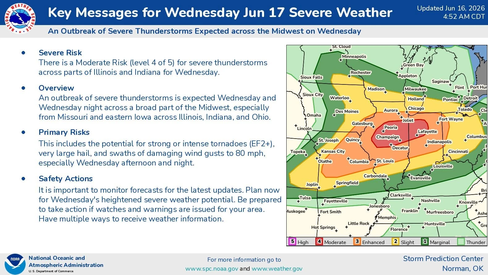
HILLSBORO — At 7:50 AM CDT Wednesday, the National Weather Service in St. Louis issued a Tornado Watch for Montgomery County, Illinois, active until at least 3 PM.
The full text of the alert is below:
TORNADO WATCH OUTLINE UPDATE FOR WT 340
NWS STORM PREDICTION CENTER NORMAN OK
750 AM CDT WED JUN 17 2026

TORNADO WATCH 340 IS IN EFFECT UNTIL 300 PM CDT FOR THE
 FOLLOWING LOCATIONS

ILC001-009-011-013-017-019-021-023-029-035-039-041-045-053-057-
061-063-067-075-083-095-099-105-107-109-113-115-117-123-125-129-
135-137-139-143-147-149-155-167-169-171-173-175-179-183-203-
172000-
/O.NEW.KWNS.TO.A.0340.260617T1250Z-260617T2000Z/

IL
.    ILLINOIS COUNTIES INCLUDED ARE

ADAMS                BROWN               BUREAU
CALHOUN              CASS                CHAMPAIGN
CHRISTIAN            CLARK               COLES
CUMBERLAND           DE WITT             DOUGLAS
EDGAR                FORD                FULTON
GREENE               GRUNDY              HANCOCK
IROQUOIS             JERSEY              KNOX
LA SALLE             LIVINGSTON          LOGAN
MACON                MACOUPIN            MARSHALL
MASON                MCDONOUGH           MCLEAN
MENARD               MONTGOMERY          MORGAN
MOULTRIE             PEORIA              PIATT
PIKE                 PUTNAM              SANGAMON
SCHUYLER             SCOTT               SHELBY
STARK                TAZEWELL            VERMILION
WOODFORD
$$
Wind Advisory to be in effect this afternoon
Also of note was a Wind Advisory, which was issued at 2:26 AM CDT. Montgomery County will be under this alert starting at 1 PM until its expected expiration at 8 PM.
The full text of the alert is below:
URGENT - WEATHER MESSAGE
National Weather Service St Louis MO
226 AM CDT Wed Jun 17 2026

ILZ058>060-064-065-069-070-074-098>101-MOZ052-060-061-063-064-172230-
/O.CON.KLSX.WI.Y.0004.260617T1800Z-260618T0100Z/
Greene IL-Macoupin IL-Montgomery IL-Bond IL-Fayette IL-Clinton IL-
Marion IL-Washington IL-Calhoun IL-Jersey IL-Madison IL-Saint
Clair IL-Lincoln MO-Warren MO-Saint Charles MO-Saint Louis MO-
Saint Louis City MO-
Including the cities of Salem, Saint Louis, Edwardsville, Cahokia,
Saint Charles, Centralia, Vandalia, Litchfield, Alton, and Belleville
226 AM CDT Wed Jun 17 2026

...WIND ADVISORY REMAINS IN EFFECT FROM 1 PM THIS AFTERNOON TO 8 PM
CDT THIS EVENING...

* WHAT...Southwest winds 20 to 30 mph with gusts up to 45 mph
  expected.

* WHERE...Portions of south central and southwest Illinois and east
  central Missouri.

* WHEN...From 1 PM this afternoon to 8 PM CDT this evening.

* IMPACTS...Gusty winds will blow around unsecured objects. Tree
  limbs could be blown down and a few power outages may result.

PRECAUTIONARY/PREPAREDNESS ACTIONS...

Winds this strong can make driving difficult, especially for high
profile vehicles. Use extra caution.

Secure outdoor objects.

&&

$$

Jake Leonard, a broadcast media and journalism veteran, is the editor-in-chief of Heartland Newsfeed. Leonard is also GM and program director of Heartland Newsfeed Radio Network, wrestling editor and contributing writer for Ambush Sports, a contributing writer for My Sports Vote and Midwest Sports Network, and a former contributor to Bleacher Report and Overtime Heroics. He resides at home in Nokomis, Ill. with his dog Buster.
Similar posts


 68°F
Feels like 69°F°L: 68° H: 69°
68°F
Feels like 69°F°L: 68° H: 69°