Listeners:
Top listeners:
-
 play_arrow
Revolution Radio Your home for the best variety of Christian music
-
 play_arrow
Heartland Newsfeed Radio Network Heartland Newsfeed Radio Network
-
play_arrow
Heartland Newsfeed Radio Network (Abovecast Backup) Heartland Newsfeed Radio Network
-
 play_arrow
Home For The Holidays Radio
-
 play_arrow
Democracy Now! 2026-07-22 Wednesday
Illinois drought impacts continue into the fall
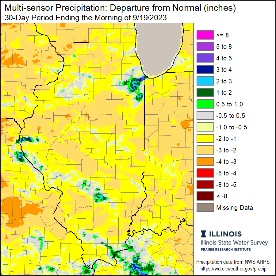
Drought re-intensified in Illinois at the end of the growing season, increasing the risk of fire and blowing dust as harvest approaches, according to Illinois State Climatologist Trent Ford at the Illinois State Water Survey. River levels have also dropped near or below low-stage, leading to navigation concerns.
Most of Illinois was 1 to 8 inches wetter than normal between mid-July and mid-August, dramatically improving soil moisture, crop conditions, and stream flow. However, drier weather has dominated since mid-August, and most of central and northern Illinois have been 1 to 4 inches drier than normal between mid-August and mid-September.
Soil moisture down to 20 inches has been depleted once again because of the below-normal rainfall. The combination of dry conditions and late August heat has also sped up crop deterioration and possibly affected some yields in the driest parts of the state. Meanwhile, crops in areas of the state that had been wetter in early August, such as parts of central and southern Illinois, have had to rely on soil moisture to finish the growing season.
The recent dry weather has quickly dried corn and soybeans. The combined low humidity and dry topsoil have increased field and grass fires across the Midwest. Extra precautions should be taken ahead of, during, and after harvest to ensure safety considering the enhanced fire risk.
Additionally, dry crops and topsoil increase the chances of blowing dust on dry and windy days. Farmers should consider the weather and the potential dust created when harvesting to avoid potentially dangerous conditions.
Persistently dry conditions this summer have also caused concerns of low water flow along the Mississippi River in the Midwest. As of Sept. 13, the Mississippi at Memphis, TN was 1.5 feet below low stage and forecasted to approach record low values by Sept. 15. The big river hit a record low of -10.81 feet on Oct. 21, 2022, so it is concerning that we are approaching these low values a full month ahead of last year.
The problem of river low flow is not as easily fixed as soil moisture drought. Most rain over the next few weeks would be soaked up by the soil to replenish soil moisture and groundwater, reducing runoff to major rivers and their tributaries. Therefore, the Midwest region will need prolonged wetter conditions over the next several weeks to help reduce or avoid the impacts of river low flow.
Outlooks show the best chances of warmer conditions returning for the last full week of September but also possibly better chances of near to wetter than normal conditions in the Midwest.
For more information about monthly Illinois weather summaries, current conditions, and climate, visit the Illinois State Climatologist website, http://stateclimatologist.web.illinois.edu.
Press Release

 63°F
Feels like 62°F°L: 63° H: 63°
63°F
Feels like 62°F°L: 63° H: 63°